Documents filed in connection with an upcoming public hearing on a bid to demolish the decrepit Foundry Branch trestle reveal a gnarly history of the site that includes dramatically different property valuations, visions of townhouse development and costly gridlock.
The fate of the circa 1896 streetcar span, abandoned around 1960 with the demise of the Georgetown-Glen Echo line, might tell much about the future of an impressive stretch of Potomac River frontage at the south end of Glover Archbold National Park, as well as the Palisades.
The “Foundry Branch trestle site” is actually two properties, leftovers from the old streetcar right-of-way. On the span’s west side is a wooded quarter-acre, which has drawn little attention. On the east side is a roughly 2.14-acre property that borders Georgetown University, a parcel that GU and WMATA have been circling for many years.
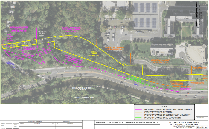
Foundry Branch “trestle site” map, showing separate properties outlined in yellow that are owned by WMATA, Source: WMATA
 Trestle site disposition fell to WMATA (Washington Metropolitan Area Transportation Authority) as part of a 1997 court-order to liquidate the “Riders” fund trust, created to settle claims about “excessive fares” by D.C. Transit, the former private bus operator. Disposal was supposed to fund purchase of new buses. But WMATA says, due to the span’s status, it has been unable to sell, donate, or even pay to transfer the properties, including to the National Park Service and GU, which each control bordering property.
Value Assignment
What the trestle-area site worth? The site is a dangerous and useless money-sucker to WMATA. To preservationists it’s a future charming and practical walker and bicyclist viaduct. More numerically, the west-side property, by a clearing at the south end of Foxhall Village, is valued at $495,170 on the D.C. property tax rolls. But the hearing documents focus on the east side property, which the D.C. tax roll values at $21,470.
A 2009 appraisal of the east side property obtained by GU came in at $84,000, with the report calling the property “steeply contoured” and an “uneconomic remnant.” The appraiser, RCDH & Co., noted in its report a 2005 “concept” plan from its client showing the potential for 20 townhouses on the site, with a road along the north side extended from an existing campus access road. The report states that the site, in its existing condition, could potentially support “a few attached townhouses or up to three detached houses”, but the “concept” plan would not meet current zoning requirements. The report stated the trestle was not part of the valuation, but that its close proximity posed a potential risk and that the “most effective mitigation” is removal.
A 2010 appraisal of the east side parcel by Integra Realty Resources for WMATA valued the site at $730,000. The appraisal noted two residential concepts “currently being contemplated”, with the report including headings for “Georgetown Terrace”. The report notes “significant land planning challenges”, but adds that the site “appears to be buildable” and speculates four to 17 home sites might be accommodated if access were available, and ventures to say that access, hypothetically, would bump valuation to $3.1 million.
The dueling appraisals, according to WMATA, were part of a settlement of a dispute arising in the early 2000s, where WMATA claimed “unlawful” expansion by GU of Fowler Road, which connects Canal Road to the GU campus and crosses the WMATA property on a GU-owned right-of-way.
In Traction
Appraisals aside, WMATA says GU isn’t interested in acquiring the site. It might be 20 to 40 years before that changes. That’s the time it would take, says the Integra appraisal, for buildable space on the GU campus to tighten to a point that might stimulate acquisition. WMATA says that neither the park service nor GU are interested in providing access to the site.
The “trestle site” tangle exacts a price. WMATA says it spent $14,860 in 2006 to install chain link fencing to block the trestle at both ends of the 260-foot, 45-foot high span and another $35,588 in 2018 to fence off the park trail, which runs under the span, to guard against people being hit by falling bridge debris. A covered walkway that had been planned was rejected because the protection would have been inadequate, according to WMATA. Trail closure is in its third year.
WMATA, which paid $31,216 for a 2014 structural assessment of the trestle, takes a dim view of the span. The agency says analysis shows the 16-inch I-beams are “presently undersized” and suggests that the basic supports were “flawed as originally constructed”. And restoration would likely cost more, in today’s dollars, than the structural assessment’s estimate of $2.1 million to $2.3 million. Estimates of the cost to remove the span have widely varied. WMATA’s figure for what it calls a four-week job is $800,000, while an estimate noted in the property appraisal for GU is $125,000.
Despite the knots, those pushing for trestle preservation have gained support, including from the National Capital Region Transportation Planning Board. The “federally designated metropolitan planning organization” announced November 6, 2018 that four bicycle and pedestrian projects in D.C. received about $1.2 million through the Transportation Alternatives program. The figure includes $600,00 for “preliminary design” for a new trail in the Palisades neighborhood involving rehabilitation of the trestle and connection to Glover Archbold, Georgetown and the Capital Crescent.
The trestle is subject to the Historic Landmark and Historic District Protection Act of 1978. The hearing on WMATA’s demolition permit application, set for 9:30 Friday morning at 1100 4th Street SW, Room E200, might determine whether any preliminary trail design leads to reality or goes down with approval of a raze permit.


